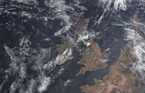
Earth observation (EO) data is collected using remote sensing technologies to monitor land, water and the atmosphere. For many, Google Maps is the most familiar application of this type of satellite-derived data. Over the past ten years, more satellites and improved methods of data capture, including infrared and radar remote sensing, have enabled increasingly accurate monitoring, and the development of more practical applications.
According to Auke Blokland, a data scientist at CGI in the Netherlands, the quality of EO data has improved drastically over the last decade because of advancements in three areas:
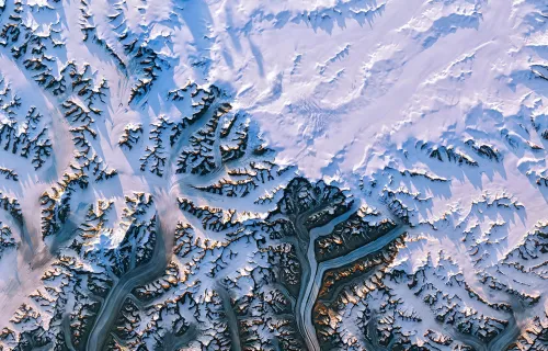
Ron Valk, who leads space data services for CGI in the Netherlands agrees. “Initially, data was only available kilometer by kilometer. Now we are up to 30-centimeter spatial resolution.” Although the resolution and quality of the information is much higher, Valk cautions, “you need more processing capacity in order to process the data.”
While processing large amounts of data can be solved by adding more processing power, a more efficient solution is developing models to reduce the processing power needed. For example, Blokland suggests focusing on detecting changes or interesting shifts, where more processing can then be done.
Repeating work already completed is another challenge in managing EO data. Valk observes that people are downloading, collecting or processing data that already is widely available. He predicts that by developing and using standardized building blocks and linking them, as CGI is currently doing, projects can start faster and make solutions more reliable.
Continuous improvements in data quality and resolution translate into practical applications and services for many industries. Blokland explains that, in the past, only large-scale changes like deforestation and melting ice caps could be monitored. Now, better resolution and more frequent satellite flights help develop more detailed services.
Valk offers a few examples, including an insurance company monitoring the integrity of a greenhouse using satellites. “On a millimeter level, we can measure changes, and we can prevent damage by notifying the owner.” Other applications include measuring thermal changes in houses and business locations to identify energy leakages or non-compliant construction activities. The same applications that measure the degradation of greenhouses can be used to monitor the integrity of oil pipelines or bridges. In fact, a range of assets can be monitored using the same technique, depending on the needs of the organization.
Harjit Sheera, director of corporate services for CGI’s global space business, predicts that environmental challenges can be better addressed through EO monitoring of wildfires, floods, oil spills and more. “The volume of satellite-derived Earth observation data will only increase, and it's clear that there are major advantages in its use, such as addressing the urgent environmental aspects we are facing today.”
To learn more about the growing opportunities for environmental monitoring from space, listen to the podcast or read the transcript.
- Introduction
-
Harjit Sheera:
Hi, and welcome to CGI’s series of podcasts, where we will be exploring the space industry in conversation with CGI’s space domain experts. Our experts have a wealth of knowledge across the space industry, and I'm delighted to share this with our listeners today. In this first series, we will be looking at how space data is used across the different industries.
I'm Harjit Sheera, director of corporate services in space. My role is business development across CGI’s global space business, and today I will be exploring Earth observation and the use of space data. Joining me today is Ron Valk. Ron is responsible for space data services within CGI Netherlands. Also, with me today is Auke Blokland, a data scientist in the space data services team, also within the CGI Netherlands business unit. Hi, Ron.
Ron Valk: Hello.
Auke Blokland: Hi.
- Understanding technologies and data collection methods used for Earth observation
-
Sheera: Thanks for joining me today. So, Earth observation is essentially the use of remote sensing technologies to monitor land, waters and the atmosphere. There are obvious advantages when these technologies are satellite-based, but can you describe the technologies that are used?
Blokland: Yes, of course. Earth observation, generally known by the public as things like Google Maps, where you can just look at the map as it's shown. But actually, Earth observation is a lot more. You can also think about infrared, which is in your remote control, but also, radar. All these little parts of remote sensing are actually coming together when we start working with remote sensing. There are different resolutions, different spatial resolutions, different temporal resolutions, so how often does the satellite actually come by and provide us with information? Then, of course, the radiometric resolution, like how dense is the information provided from the satellites?
Sheera: Can you expand on the tradeoff between the different remote sensing technologies?
Blokland: Yes, so what happens, for example, during natural disasters is that the optical satellites are blocked because of clouds. Imagine there is a hurricane, then there are a lot of clouds. The optical satellites don't see anything except clouds, and the radar satellites, the radar actually penetrates the clouds. We can still get an image on the ground surface of what is happening there. We can still see with radar data if there are houses which are completely ruined, or maybe we want to find an airfield, where not a lot of damage is taken. We can actually send people there with first responders to help people who are affected by a hurricane.
Sheera: What kind of data can you get from the methods that we use?
Blokland: The types of data are mainly divided in two parts. You have the optical data, which is like a passive sensor. It just detects what is reflecting back from the Earth's surface. The second part are the active sensors, and active sensors actually send a signal to Earth, and then detect the reflection. Those are two types of satellites which are now in orbit, and both of them are really useful, depending on the situation.
Sheera: What are the benefits, though, of using all of the data from all of the various Earth observation satellites that you've just described?
Blokland: Actually, the combining of data is really useful when we're going to work on a solution, because the one has more benefit than the other in certain kinds of situations. But in general, satellite data is really useful because satellites are orbiting the Earth like 24/7, 365 days a year, so you don't really need someone to go somewhere to catch an image, or fly a drone, or fly a helicopter, fly a plane — that isn't really necessary. The satellites are already there and taking in information every moment when they fly by. Also, what is really nice is that satellites are monitoring really consistently, so every shot is taken with the same characteristics. When you go out in a field and you take a photo with your camera, then you can change the ISO values and such, and with space data, that is all consistent. Every time you get an image, you can compare it easily to the previous one and to the next one.
- Tracking the evolution of space data
-
Sheera: Okay, so how is the quality of the space data that you're using? How has that changed say over the last 10 years or since you've been in the field?
Blokland: What you can see is that there's a trend in smaller and smaller exercises, so the thing is that in the previous decade, the satellites were really coarse, and you could only see the bigger areas, and not much detail. But with more and more satellites in space, you get better and better resolutions. Also, you see that it becomes really cost effective, so it becomes cheaper. With SpaceX, you get cheaper launches, so the satellites also provide cheaper data. What also is really, really easy is that, what I mentioned before, the historical data is always available. You can also look back, see the results, and compare that with the new satellites, the new images taken in.
Valk: Initially, data was available one square only, one kilometer by one kilometer. Now we are up to 30 centimeter spatial resolution, so it's widely available. The resolution, the quality of the information is much higher. Of course, there's a trend that you need more processing capacity in order to process the data.
- Solving challenges related to data quality and resolutions
-
Sheera: Yeah, that was going to be my next question. I can imagine that with all of the greater capacities and the more processing that you're doing, you must have some additional challenges, as well. Can you describe some of those challenges that the market faces in trying to improve the data quality and the resolutions that you have?
Blokland: Yeah, so the problems we're facing are also tackled by companies like Microsoft and Google. They provide a lot of cloud computing solutions. Some of the problems we face with processing large amounts of data can be solved by just putting in more processing power, but on the other hand, we also try to develop models to reduce the amount of processing power needed. You could just simply process it all, but you could also detect changes. Then on the places where there are changes, which are interesting, do more processing there. So, there are two ways of tackling this problem.
Valk: Another thing, which is also I think relevant, is that we've seen a lot of projects that people are starting from the beginning, so more or less reinventing the wheel. They are, for example, downloading data, or collecting data, or doing some pre-processing, like cloud removals, and all that kind of stuff. We see a trend and an advantage, too, by using standardized building blocks we developed, and linking them together into … a service, so we are able to start faster, and make our solutions more reliable. Because the building blocks themselves have already proven themselves, they're efficient in their processing. They are helpful in our development, so we have one challenge: a lot of projects start with the basics, which are widely available already.
- Helping organizations manage increasing amounts of data
-
Sheera: The volume of data available is ever increasing, as are the processing and manipulation methods. In your opinion, are organizations able to make the most of what's available and what can be done with the data today?
Valk: Yeah, I think because a lot of our clients are doing this, and what I also see with other colleague companies, is that there are a lot of concept proof values and that the advantage of satellite data is being proven. But the next step to that then, our business or our clients identify — okay, we also need to have an organizational change, because in the procedures it’s described that the measurements need to be done in a certain way. Of course, using space data will impact that way of working. I think that's something that I see with some organizations that they sometimes forget to think about it. Okay, what comes after the successful proof of concept or proof of value? Even if the business case is positive, it still sometimes ends with those struggles, which is those challenges.
Sheera: How do you see these trends translating into applications and services?
Valk: There are multiple potential solutions that are widely available. Because, for example, in the Netherlands, we have an insurance company who is monitoring greenhouses using satellites on their deformation. On a millimeter level, we can measure the changes of the greenhouse, and we can prevent damage by notifying the greenhouse owner: okay, your greenhouse is deforming, and please be aware before the glass in the greenhouse breaks, you have to take some measurements. That's something. And then another thing is measuring thermal changes. Identifying if there are some energy leakages of houses, for example. You can measure using space data on a very detailed level the temporal changes of, for example, houses, also business locations, and to identify if there are illegal activities within those constructions. Those are some examples of how space data is being used, and also to identify crop fields, that's also widely used. But, of course, in the initial days, space data was used for, and there was quite a focus on climate asset management, of course, but initially it was used for large-scale monitoring.
- Using and applying space data: future trends
-
Sheera: Going forward, what sort of trends can you see with the use of these applications and services? How do you think the services will develop as space data availability or quality will change going forward?
Blokland: The big thing I think will change is that, in the past, you could only monitor large-scale changes, so think the climate changes, big scale deforestation, melting of the ice caps, that are the large-scale things you could monitor. Now, with improvement in satellites, you get better resolutions, you get better temporal resolution, so satellites fly by more often. That trend actually helps us to develop services which are more detailed. You could go from large-scale forest solutions to downscale it towards one greenhouse or one building you can monitor. That really helps us in developing more and more solutions, which people didn't even think about. Think of the subsidence, we can now measure a millimeter subsidence if buildings, or bridges, or whatever, are deforming. Well, the thermal monitoring, previously, it was pixels of about 500 meters. We can now bring it down all the way to 50 centimeters, so you can actually see heat changes or differences on one rooftop. These possibilities really, really help in finding new clients, and further developing the presence of space data.
Valk: Also, using this data, it can automate for people, less attractive work, of course, because we do it in a consistent way. You can measure consistently and you're not dependent on the person's opinion. That's, I think, an advantage of using space data. Another thing is the trend that people are becoming older and older. There is a lack of resources for people who want to do some more standardized inspections, or also, impacted by COVID, there was less travel allowed. Using space data, you can also monitor remote areas. For example, we are based in the Netherlands; we can monitor from the Netherlands, we can monitor assets around the globe. That's another advantage and a trend, which I see coming from our customers, that they want to see something which is not currently physically available.
Sheera: Thanks for that, Ron and Auke, you've discussed some very interesting solutions that address some very specific requirements, such as detecting the thermal variations and the subsidence in greenhouses. But I would be interested to know how easily the same applications or solutions can be applied to more than one industry, this question is to the both of you.
Valk: Yeah, that's what we try to do with our CGI EnvironmentMonitor 360 (solution), that's based on building blocks, and connecting those building blocks, we can define all kinds of services. These services can be applied to multiple use cases or multiple clients. For example, as Auke mentioned, the deformation of the greenhouses, the same, of course, applies for monitoring oil production sites. Pipelines can be monitored, but also bridges, as Auke also referred to. All kinds of assets can be monitored using the same technique, and depending on the customer, it can be or needs to have some adjustment. But in principle, the techniques are the same, the same for our thermal service that can be used for monitoring, technical installations — is there a temperature change? Also, is there some leakage from heat pipes? All kinds of use cases can be applied to the same type of services.
- Conclusion and wrap-up
-
Sheera: Auke and Ron, thank you so much for your contribution today. Your experience across the industry has provided us all with a lot of very useful information, and thank you very much.
Blokland: Yes, thank you, and thank you for giving me a platform to promote Earth observation data.
Ron: Thank you for your interest in remote sensing and looking forward to speaking to you soon.
Sheera: Thanks, Ron. Thanks, Auke. We've learned that satellite-derived Earth observation data has evolved significantly over the last few years, with more satellites and improved methods of data capture allowing monitoring to centimeter accuracy. This accuracy, along with the processing techniques, enable applications and services to be developed that meet more stringent requirements. Where previously only large-scale monitoring was possible, we can now monitor individual buildings and temperature changes within specific zones of these buildings.
Our environmental challenges can be better addressed through monitoring wildfires, oil spills, and making efficiencies in labor and costs. However, this also comes with challenges, with increased volumes of data requiring more processing power, and efficient methods for processing. In addition, many organizations, such as utility companies, are not always able to take full advantage of what can be done with the data today, due to evolutions required in their processes and infrastructure for handling this data. In any case, the volume of satellite-derived Earth observation data will only increase, and it's clear that there are major advantages in its use, such as addressing the urgent environmental aspects we are facing today. We hope that this podcast and the views of our experts have given you some insights into the market, thank you everyone for listening.